
FPSAT
Addtime:2014-11-18 11:50
FPSAT
——Flight Procedure Satellite Analysis Tool
FPSAT
These activities include checking the coverage and accuracy provided by the navaids infrastructure along the whole of a procedure’s trajectory and identifying any electromagnetic interference that may affect the performance of the navaids infrastructure.
A virtual flight inspection of an RNAV procedure may also be used to verify and optimize:
• The obstacle environment where the procedure is located
• The flyability of the procedure
FPSAT is a pre/post processor that enables procedure specialists to:
• check how the FMS (flight management system) will fly the coded procedure by comparing the nominal trajectory and the simulated trajectory taking into account:
• ARINC path and termination
• type of aircraft as per BADA files
• kinematic constraints
• weather constraints
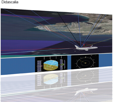
• verify GNSS (global navigation satellite system) signal in space performance (GPS, SBAS, GBAS) along a trajectory
• assess the signal continuity, coverage and couples availability of DME/DME navigation along a trajectory
• visualize ATS related geographic data, perform diagnostics and check the results for their functionality
• review procedures to optimize navigation performance,cost and environmental impact.
Main Features
• Automatic Loading of complex SID, STAR and approach data into the procedure design graphic environment.
• Load data from different sources e.g. IDS FPDAM and/or IDS EMACS
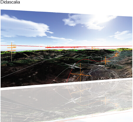
• 3D visualization of terrain information
• 3D visualization of aircraft trajectory and RNP tunnel
• “Out of the Window” view with animation along a trajectory
Electronic Navigation Aids
FPSAT covers the need to verify the availability and usability of electronic navaids (satellite and ground based signals) along a flight path:
• for a given realistic aircraft attitude
• for a specific aircraft category
• for different takeoff loads and weather conditions
• considering the variability of the GPS constellation
• for different types of GPS augmentation
• taking into account changes in the electromagnetic environment due to interaction with potential sources of interference
Post Processing
Navigation Satellite System (GNSS) FMS Post-Processing covers:
• ARINC 424 compliancy check
• selection of different aircraft types
• performance analysis according to weight, bank angle and speed
• weather and atmospheric conditions
DME/DME Post-Processing covers:
• number of available and usable DMEs and DME pairs
• critical DMEs
• local continuity
• min and max Position Estimation Error
GNSS Post-Processing:
• performs signal in space required navigation performance (SIS RNP) checks along a flight path
• visualizes detectable, monitored (SBAS) and usable satellites
• Calculates navigation system error (NSE) and horizontal and vertical position errors (HPE, VPE)
• plots horizontal and vertical protection levels (HPL,VPL)
• GBAS (ground based augmentation system) analysis
Prev:Airspace Designer
Next:FPDAM