
EMACS
Addtime:2014-11-18 10:54
EMACS
——Electromagnetic Airport Control and Survey
EMACS
EMACS, ElectroMagnetic Control and Survey, applies advanced simulation techniques to assess the performance of Communication, Navigation and Surveillance (CNS) systems and is able to be fully integrated and interoperable with navigation and AIS/AIM data. It helps to improve the effectiveness of CNS equipment thus improving safety and also reducing the cost of flight inspections.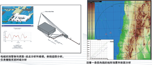
EMACS is composed of a modular set of validated 3D modeling and simulation tools capable of coping with ElectroMagnetic Compatibility (EMC) issues and ElectroMagnetic Interference (EMI) problems within the complex environments of airports and air navigation sites.
The modeling functionality (including terrain models,obstacles, interfering systems, ground and airborne navaid equipment characteristics etc.) allows the user to model the propagation of real phenomena taking place within a complex electromagnetic airport scenario where artificial or natural obstructions can interfere with navaid signals. It can be used to investigate the performance of a variety of navigation systems including: VOR, DME, ILS, ATC Radar and GPS systems.
Electromagnetic Analysis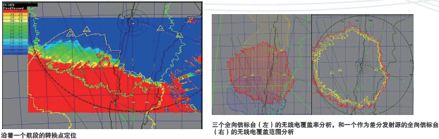
EMACS enables the user to calculate and simulate the same electromagnetic features of installed navaids that are typically inspected during commissioning or standard periodical flight checks. Furthermore, EMACS is capable of investigating potential changes in the environment surrounding a navigation aid (e.g. the impact of new building construction) and predicting the electromagnetic performance of any planned navigation facility.
The system is based on a layer of graphical (CAD) and geographical (GIS) functions for constructing and visualizing 3D elements on a geographic continuum using all types of datum and projections (e.g. WGS84).
EMACS allows the user to create a numerical model of the equipment under analysis and an electromagnetic model of the environment surrounding it. EMACS then performs a numerical analysis on the data provided and generates a visual representation of the computed electromagnetic field and the associated air navigation quantities (e.g. DDM, coverage limits, etc.). EMACS also has built-in parameter tools to simulate the behavior of on-board aircraft receivers.
Basic and Multi Coverage
Basic and Multi Coverage is the core module of the EMACS system providing the following basic functions:
• Project management of the geographical and electromagnetic projects handled, workspaces and user designs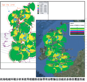
• Database connection management and interface
• User administration
• Configuration of the project data on the network and among the users
• Network and program configuration for electromagnetic analyses
• Task scheduler for electromagnetic numerical analysis execution
Basic and Multi Coverage provides numerical tools for the following tasks:
• Digital Terrain Model inspection by means of a probe function and terrain profiles extraction along polylines and/or circles
• Fresnell ellipse analysis
• CAD modeling of the environment around the TX(transmitter) antenna
• Radio coverage evaluation at a constant altitude or height and along a route segment
• Antenna pattern definition and modeling
• CNS equipment coverage redundancy assessment
EMACS Modules
EMACS is a modular system with each module devoted to a specific type of computational analysis (e.g. Basic Coverage, EMI risk analysis, wind farm analysis,multilateration) or to a specific kind of equipment (e.g. ILS,DME, VOR, ATC).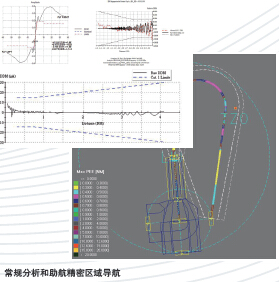
Modules available for EMACS are:
• Wind Farm - Wind Farm impact assessment
• ASUV - RNAV performance evaluation
• ILS - Instrument Landing System precision analysis
• VOR - VHF Omnidirectional Range precision analysis
• DME - Distance Measuring Equipment precision analysis
• Radar - Radar performance evaluation
• Ground-Air communications - VHF link analysis
• EMI - Electromagnetic Interference evaluation around CNS equipment
• MLAT - Airport Multilateration systems performance analysis
• WAM - Wide Area Multilateration systems performance analysis and simulation
Prev:FPDAM
Next:e-TOD